Dendritic : Drainage Pattern resembling branches of tree eg : rivers of N India
Radial : Rivers orig from hill & flow in all directions eg Amarkantak Range
Trellis : When Primary Tribut flow // to each other & Secondary Tributs join them at _|_ angles
Centripetal : Rivers discharge their waters from all directions in a lake / depression
River Basin : Catchments area of large Rivers ; Watershed : Catchment of small rivulets & rills ; Diff : Area ( Watershed < River Basin)
Why are River Basins / Watersheds accepted as most apt micro, meso or macro planning regions ?Ans ) River Basins & Watersheds are marked by unity ; what happens in one part directly affects the other part or unit
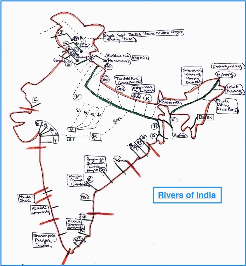
Indian Drainage sytem div on basis of discharge of water : (1) Arabian Sea Drainage ( 77% ) (2) Bay of Bengal Drainage ( 23% )
—> Separated from each other by Delhi Ridge , Aravalis & Sahyadris
On Basis of size of watershed
Major River Basins : > 20,000 sq km of Catchment Area ( 14 ) ( Ganga Brahmaputra Krishna Narmada Tapi Mahi Sabarmati )
Medium River Basins : 2,000 – 20,000 sq km of Catchment Area ( 44 ) ( Kalindi, Periyar, Meghna )
Minor River Basins : < 2000 sq km Catchment Are
Himalayan Drainage System
Rivers are perennial ; fed by melting of snow & precipitation —> form V shaped valleys, deep gorges, rapids & waterfalls
When entering plains Rivers form Depositional Features : flat valleys, ox-bow lakes, flood plains, braided channels & deltas
enters Ganga plains in Champaran ; joins Ganga at Sonpur near Patna
4) Kosi :
Orig : N of Mt Everest in Tibet where mainstream Arun rises
Antecedent river
Forms Sapt Kosi after uniting with river Arun
5) Mahananda :
Orig : Darjeeling Hills
Joins Ganga as last left bank tribut in WB
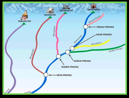
1) Yamuna :
Yamuna : Yamunotri glacier of Banderpunch range ; joins Ganga at Prayag (Allahabad)
Right bank Tri : Chambal, Sind, Betwa & Ken ( orig in Penin Plat )
Left Bank tribut : Hindan, Rind , Sengar, Varuna
Chambal :
Orig : near Mhow in Malwa Plat of MP
Flows N through Gorge upwards of Kota, where Ghandhisagar dam constructed
From Kota traverses down to Bundi, Sawai Madhopur & Dholpur —> finally joins Yamuna
Chambal famous for Badland Topo called Chambal ravines
Banas : arises in Aravalli ; only tribut of Chambal
2) Son :
Orig : Amarkantak Plat
Largest south Bank tribut of Ganga , joins Ganga in Arrah, W of Patna
3) Damodar :
Orig : E margins of Chotanagpur Plat where flows through rift valley & finally joins Hugli
Main triibut : Barakar
Damodar once named as “Sorrow of Bengal” ; now tamed by Damodar Valley Corporation
BRAHMAPUTRA Drainage SYSTEM :
Orig : Chemayungdung glaciers of Kailash range near Mansarovar
Travels E (1,200 km) in dry flat S Tibet , a.k.a. Tsangpo (the purifier) (Rango Tsang-po is major R Bank Tribut )
Comes out of deep gorge in C∆H near Namcha Barwa —> enters foothills as Dihang —> enters India W of Sadiya town in AP—> Flowing SW receives main L Bank tributs Dibang & Lohit —> thereafter known as Brahmaputra
In Bangladesh, Tista joins it on its R Bank —> henceforth known as Jamuna —> Finally merges with Ganga —> Hence called Padma
Brahmaputra well known for floods, channel shifting & erosion : most tributs bring large sediments owing to heavy RF in catchment area
Peninsular Drainage System
Older than ∆H drainage system : evident from broad, largely graded shallow valleys & maturity of rivers
W Ghats acts as water divide betw 2 oceans
Penin R char by fixed course, absence of meanders & non-perennial flow of water ; Exception : Narmada & Tapi flow through Rift valley
3 MAJOR Geological events of Past viz shaped Penin Drainage systems :
Subsidence of W flank of Penin —> submergence below sea (Tertiary Period ) —> disturbing symmetrical plan of river on either side of original Watershed
Subsidence & conseq Trough Faulting of N flank of Penin —> Narmada & Tapi flow in trough faults & fill orig cracks with deritus materials . Hence lack of Alluvial & deltaic deposits in N & T
Slight tilting of Penin from NW to SE dir gave orientation of entire drainage sys towards Bay of B
EAST : Peninsular Drainage System
1) Subarnarekha :
Bengal-Odisha
2) Baitarni + Brahmini :
(Odisha)
3) Mahanadi :
Orig : Raipur, Chattisgarh & runs through Odisha
4) Vamsadhara :
AP
5) Godavari :
Orig : Nasik, Maharashtra ; Largest Penin river ; Dakshin Ganga
Maj Tributs : Penganga, Indravati, Pranhita + Manjra (RB)
Godavari subj to heavy flood in lower reaches of Polavaram ( picturesque gorge )
6) Krishna :
Orig : Mahabaleshwar in Sahyadri ; 2nd Largest E flowing Penin R
Maj Tributs : Koyna, Bhima Tungabhadra
7) Penner :
AP
8) Palar :
TN
9) Kaveri :
Orig : Brahmagiri Hills, Kogadu district Karnataka
Kaveri carries water th.o. year ( Upper CA during SW Monsoon & Lower CA during NE Monsoon )
Tributaries : Kabini + Bhavani + Amravati
10) Vaigai
TN
WEST : Peninsular Drainage System
0) Luni :
Largest river system of Rajasthan, west of Aravali ; Ephemeral nature
Orig : Pushkar in 2 branches : Saraswati & Sabarmati ; join at Govindgarh
1) Sabarmati & Mahi :
Gujarat
2) Dhadhar :
Gujarat
3) Narmada :
Orig : Amarkantak plat
flows in Rift valley betw Satpura in S & Vindhyan in N
Dhuandar waterfall in Jabalpur + Sardar Saarovar Proj
4) Tapi :
Orig : Multai in Betul District of MP
5) Mandovi + Juari
Goa
6) Kalinadi
Sharavasti
Karnataka
7) Bharathpuza
Periyar
Pamba
Kerala
Himalayan River Vs Peninsular River
ASPECT
HIMALAYAN Rivers
PENIN Rivers
Place of Origin
∆H covered with Glaciers
Penin Plat & C. Highlands
Nature of flow
Perennial ( receive from Glacier & RF )
Seasonal ( Dep on Monsoon RF )
Type of Drainage
Antecedent —> dendritic pattern in plains
Super imposed —>Trellis, Radial & Rect
Nature of River
Long course flowing through rugged mtns
—> Headward erosion & River capturing
In Plains, meandering & shifting of course
Meandering is a mature/old age phenomenon
Smaller, fixed course with well adjusted Valleys
Ox bow lakes (Old Stage)
Catchment Area
V. Large Basins
Relatively smaller Basin
Age of River
Young, youthful, active & deepening in Valleys
Old Rivers with graded profile, have almost reached their base levels


 : Features & Tributaries")

 : Tributaries, Major Dams & Catchment Area | UPSC Notes")


")

 | Sociological Thinkers | UPSC Sociology Notes")