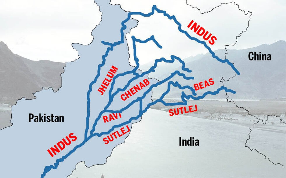
The Indus river area is one of the longest in the world. It is sometimes called Sindhu. The river flows through China (the Tibet area), India, and Pakistan. In Tibet, it is called Singi Khambai, which means “mouth of the lion.”
• The Himalayan river systems are made up of the Indus, the Ganga, and the Brahmaputra.
• The Himalayan Rivers were there before the Himalayas were formed, that is, before the Indian Plate crashed into the Eurasian Plate. • They were running into the Tethys Sea. The water for these rivers came from what is now Tibet.
• It is clear from the deep canyons of the Indus, Satluj, Brahmaputra, and other rivers that they are older than the Himalayas.
• They kept flowing during the building phase of the Himalayas. Their banks rose steeply while their beds went lower and lower due to vertical erosion (Vertical down cutting was significant and was happening at a rate faster than the Himalayas were rising), making deep gorges.
Indus River System
It starts in a glacier near Bokhar Chu in Tibet at an altitude of 4,164 m in the Kailash Mountain range near the Mansarovar Lake. It flows northwest and enters India at a place called Demchok in the Ladakh area. The Indus River runs between the Karakoram Mountains and the Ladakh Mountains, but it is closer to the Ladakh Mountains. At a place called Dungti, the river makes a quick turn to the southwest and cuts through the Ladakh range. It then turns to the northwest and flows between the Ladhak Range and the Zaskar Range towards the Leh area of Ladakh. Once it gets to Leh, the river keeps going north-northwest until it gets to the town of Batalik, which is in the Kargil district.
At Leh, it meets the Zaskar River.
About 2,700 m above sea level, it meets the Shyok near Skardu.
The Gilgit, Gartang, Dras, Shiger, and Hunza are all rivers that flow into the Indus from the Himalayas.
• The Indus river now flows into the Baltistan region through the city of Sakardu and continues to flow northwest towards the city of Gilgit. When it gets to the city of Gilgit, the river makes a turn to the south and then a turn to the west. It then flows into Khyber Pakhtunkhawa, which is the northwest frontier province of Pakistan.
Near the city of Attock in Pakistan, the Kabul River flows into the Indus River. It is the main river in eastern Afghanistan and the Khyber Pakhtunkhwa province of Pakistan.
• The river then flows southwest and continues to flow through the Khyber Pakhtunkhwa province.
• The river then flows through the plain in the western and southern Punjab provinces of Pakistan and continues to flow towards the Sindhu province of Pakistan.
The water from the Jhelum, the Chenab, the Ravi, the Beas, and the Satluj flows into the Indus from Panjnad, which is just above Mithankot. In Sindh Province, the river picks up a lot of sediment and forms the Indus river delta before emptying into the Arabian Sea near Karachi. The blind Indus River Dolphin is a subspecies of dolphin that can only be found in the Indus River.
• The largest rivers that flow into it from the left bank are the Zaskar, Suru, Soan, Jhelum, Chenab, Ravi, Beas, Satluj, and Panjnad rivers.
• The main rivers that flow into it from the right bank are the Shyok River, Gilgit River, Hunza River, Swat River, Kunnar River, Kurram River, Gomal River, and Kabul River.
Shyok River
The Shyok River starts in the Karakoram Range and runs through Northern Ladakh in J&K. It is about 550 kilometres long.
It flows into the Indus River from the Rimo Glacier. It gets wider where it meets the Nubra River. The Shyok River forms a V-shaped bend around the south-eastern edge of the Karakoram hills.
Nubra River
The main source of the Nubra River is the Nubra Glacier, which is in a valley east of Saltoro Kangri Peak. The Nubra River flows into the Shyok River.
The Nubra River winds to the southeast and meets the Shyok River downstream of Shyok Valley at the base of the Ladakh range. The Nubra River forms Nubra Valley, which is 3048m above sea level. The catchment area is devoid of plants and people because it is high up and doesn’t get much rain.
Shigar River:
• It is a small river that flows into the Indus River on the right bank as it flows through the Ladakh area of J&K.
It starts at the Hispar Glacier and flows to the Indus River at Skardu. It flows down a very steep slope to join the Indus River. Its entire watershed has been affected by glaciers.
Gilgit River:
• It is an important right-bank tributary of the Indus River as it flows through the Ladakh region of Jammu and Kashmir;
• It flows from a glacier near the extreme northwestern edge of the Himalayas; and
• It flows into the Indus River.
The area where the Gilgit River flows into the sea is barren and empty. Bunji is the main town along the river. Ghizar and Hunza are the main rivers that flow into the river from the right and left banks, respectively.
Hunza River
The Hunza River is an important left-bank tributary of the Gilgit River. It comes from a glacier north of the Karakoram Range in the northwestern part of J&K. It flows southeast and cuts across the Karakoram Range through a spectacular gorge. Downstream, the Hunza River follows a southwesterly direction in its middle course. Then it cuts across an offshoot of the Karakoram range and changes course to the southeast in its lower course before merging with
Zanskar River:
• It is one of the important rivers that feed into the Indus.
• There aren’t many places where people live.
Chenab River
• The Chenab starts near the Bara Lacha Pass in the Lahul-Spiti part of the Zaskar Range.
• It is formed when the Chandra and Bhaga rivers meet at Tandi in the upper Himalayas in the Lahul and Spiti District of Himachal Pradesh.
• In its upper reaches, it is also called the Chandrabhaga.
• It flows through the Jammu region of J&K and into the plains of Punjab in Pakistan
Jhelum River:
• It is a branch of the Chenab River and is 813 km long;
• It starts at a spring at Verinag, which is at the foot of the Pir Panjal in the southeastern part of the Kashmir valley in India;
• Its largest branch, the Kishenganga (Neelum) River, joins it.
• The Chenab and the Sutlej join together to make the Panjnad River, which flows into the Indus River at Mithankot.
Under the rules of the Indus Waters Treaty, Pakistan gets the water from the Jhelum. The Jhelum flows into the Chenab in Pakistan.
Kishanganga River
• It originates at Drass in the Kargil district of J&K
• The Neelam River enters Pakistan from India near the Line of Control and then runs west till it meets the Jhelum River
• It is also called as Neelam River (Neelum) either due to its sky cold water or due to the precious stone “ruby (Neelam)” that is found in this area
• It is famous for ice-cold water and trout fish.
Ravi River:
The Dhauladhar range of the Himalayas in the Chamba district of HP is where the Ravi River starts. Ravi starts in the Kullu hills near the Rohtang Pass in Himachal Pradesh. It flows northwest and is a perennial river that is about 720 km long. The waters of the Ravi River belong to India because of the Indus Waters Treaty. The Ranjit Sagar Dam (also called the Thein dam because it is in Theinvillage) is the largest multipurpose project built on the river. Chamba town is on the right bank of the river.
It is planned to build the Ujh Multipurpose Project on the River Ujh in the Kathua area of Jammu and Kashmir. The Shahpurkandi Dam project will be built on the Ravi River in the Pathankot area of Punjab, just downstream from the Ranjit Sagar Dam.
Sutlej River
The Sutlej River is sometimes called the “Red River.” It starts beyond India’s borders on the southern slopes of the Kailash Mountain, near Mansarover Lake and Rakas Lake, and flows southward through Kinnaur, Shimla, Kullu, Solan, Mandi, and Bilaspur districts. It leaves HP at Bhakra and flows into the plains of Punjab, where the world’s highest gravity dam, the Bhakra Nangal Dam, has been built
• There are many hydropower and irrigation projects on the other side of the river, like the Kol Dam and the Nathpa Jhakri project.
River Beas
• In HP, the Beas River, which is an important part of the Indus River System, flows out of Rohtang pass.
Before going into Pakistan, the river joins with the Sutlej River at Hari-Ke-Pattan in Punjab. This river is 460 km long, and it flows through HP for 256 km.
• Manali’s tourist spots are on the right side of the River Beas.
________________________________________
Indus Waters Treaty 1960
• The Indus system is made up of the main Indus River, the Jhelum, Chenab, Ravi, Beas, and Sutlej rivers. The basin is mostly shared by India and Pakistan, with a small amount going to China and Afghanistan. In 1960, India and Pakistan made a treaty that gave India exclusive use of the waters of three rivers: the Ravi, the Sutlej, and the Beas.
• While the waters of the Western rivers (Indus, Jhelum, and Chenab) were given to Pakistan, India was allowed to use some of them for household, non-consumptive, and agricultural purposes, as stated in the Treaty.
• India has also been given the right to use run-of-river (RoR) projects on the Western Rivers to make hydroelectricity, as long as they meet certain standards for design and operation.
Present Developments
• India has built the Bhakra Dam on Satluj, the Pong and Pandoh Dam on Beas, and the Thein (Ranjit Sagar) Dam on Ravi so that it can use the water from the Eastern rivers, which has been given to India for its own use.
• Other projects, such as the Beas-Sutlej Link, the Madhopur-Beas Link, and the Indira Gandhi Nahar Project, have helped India use almost all (95%) of the water from the Eastern rivers.
• However, about 2 Million Acre Feet (MAF) of water from the Ravi still flows to Pakistan below Madhopur every year without being used.
• The following steps have been taken to stop the flow of these waters, which belong to India and are used there:
Shahpurkandi Project:
This project will help J&K and Punjab use the water that comes out of the generator of Thein dam to water crops and make electricity. The building work is being done by the Government of Punjab with help from the Government of India.
The Ujh multipurpose project is being built. This project will store water on the river Ujh, which is a tributary of the Ravi, so that it can be used for agriculture and to make electricity in India. This project is a National Project, and it will take 6 years to finish from the time it starts being done.
The 2nd Ravi Beas link below Ujh: This project is being planned to take advantage of the extra water moving down the river Ravi into Pakistan, even after the Thein Dam is built. This will be done by building a barrage across the river Ravi to redirect water through a tunnel link to the Beas basin. The Indian government said that this project was a National Project.
• The three projects above will help India use all of the water it was given as part of the Indus Waters Treaty in 1960.


 : List, Names, Map, Importance | UPSC Notes")


 | UPSC Notes")


 : Features & Tributaries")
 : Tributaries, Major Dams & Catchment Area | UPSC Notes")
 : Features & Their Tributaries")