• The Cauvery River (Kaveri) is called the “Ganga of the South” or “Dakshi Bharat ki Ganga.”
• At Talakaveri on the Brahmagiri range, near Cherangala village in the Kodagu (Coorg) district of Karnataka, the Cauvery River begins at an elevation of 1,341 m.The river is 800 km long from where it starts to where it ends.It flows southeast for 705 km through the states of Karnataka and Tamil Nadu and down the Eastern Ghats in a series of big falls. Before it empties into the Bay of Bengal south of Cuddalore, Tamil Nadu, it splits into a lot of smaller rivers, making a wide delta called the “garden of southern India.”
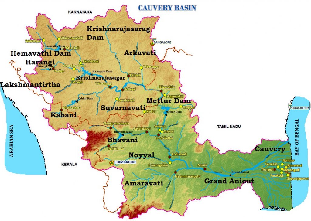
• The Cauvery basin drains an area of 81 thousand square kilometres in the states of Tamil Nadu, Karnataka, Kerala, and the Union Territory of Puducherry. It is surrounded by the Western Ghats on the west, the Eastern Ghats on the east and south, and ridges that separate it from the Krishna basin and Pennar basin on the north. The Nilgiris, which are an extension of the Western Ghats, run eastwards to the Eastern Ghats and divide the Black soils, red soils, laterites, alluvial soils, forest soils, and mixed soils are the most common types of soil in the area. A lot of the basin is made up of red dirt. In the delta, the dirt is made up of alluvium.
• Most of the rain that falls in Karnataka comes from the S-W Monsoon and some comes from the N-E Monsoon. The North-East Monsoon brings a lot of water to the area in Tamil Nadu.
In the summer, the south-west monsoon brings rain to its upper catchment area. In the winter, the north-east monsoon, which is moving away, brings rain to its lower catchment area.
It is almost a permanent river because its flow changes less than most and it is very useful for agriculture and making hydroelectric power.
Around Sivasamudram are the beautiful Sivasamudram Falls, which drop 100 metres and spread out 300 metres when it rains.
• The Kolar Gold Fields, Mysore, and Bengaluru all get their electricity from the falls.
So, the Cauvery is one of the best-managed rivers, and between 90 and 95 percent of its capacity for irrigation and power production is already being used. The river empties into the Bay of Bengal. Most of the basin is made up of farmland, which takes up 66.21% of the total area.
Tributaries of the Cauvery River
• The Harangi, the Hemavati, the Shimsha, and the Arkavati are on the left bank.
• On the right bank, the Kabbani, the Suvarnavati, the Bhavani, the Noyil, and the Amaravati all meet.
• The 101-meter-high Sivasamudram Waterfalls are where the river flows from the South Karnataka Plateau to the Tamil Nadu Plains.
• At Shivanasamudram, the river splits into two parts and drops 91 metres in a series of rapids and falls.
The power station at Shivanasamudram uses the falls at this point to make electricity. After the falls, the two branches of the river join and flow through a wide gorge called “Mekedatu” (Goats Leap). The river then continues to form the boundary between Karnataka and Tamil Nadu for 64 km.
At Hogennekkal Falls, it turns south and flows into Mettur Reservoir. About 45 km below Mettur Reservoir, a branch called Bhavani meets Cauvery on the right bank. After that, it flows through the hills of Tamil Nadu.
• Two more tributaries, Noyil and Amaravathi, join the river on the right side. At this point, the river gets wider and flows as “Akhanda Cauvery” because its bed is made of sand.
• As soon as the river passes through the Tiruchirapalli area, it splits into two parts. The northern part is called “The Coleron,” and the southern part is still called “Cauvery.” This is where the Cauvery Delta starts.
After flowing for about 16 km, the two branches meet again to make Srirangam Island. On the Cauvery branch is the “Grand Anicut,” which is said to have been built by a Chola King in the 1st century A.D.
• Below the Grand Anicut, the Cauvery branch splits into two rivers: the Cauvery and the Vennar.
• These branches split and split again, making a network of smaller branches all over the delta.
HEMAVATI
HEMAVATI is an important branch of the Kaveri River. It starts in the Western Ghats at an elevation of about 1219m near Ballalarayana Durga in the Chikmagalur District of Karnataka and flows through Chikkamagalooru, Hassan District, and Mysore District before joining the Kaveri near Krishnarajasagara. It is about 245 km long. On the river at Gorur in the Hassan area, a big lake has been built.
SHIMSHA
• It originates at an altitude of 914 m from the Devarayanadurga hills in the Tumkur District of Karnataka
• It is one of the tributaries of the river Kaveri
• Maddur is a major town that lies on this river
• Markonahalli Dam is a dam built across the river Shimsha in the Kunigal Taluk of Tumkur district
• Shimsha has a waterfall at Shimshapura in Malavalli Taluk
• This is also the location of the Shimsha Hydro Electric Project.
ARKAVATHY RIVER:
This 161-km-long river starts at the Nandi Hills in the Chikkaballapur district of Karnataka. It flows through Kolar District and Bangalore Rural district before joining the Kaveri River at Kanakapura, which is called Sangama in Kannada. The river empties into the Chikkarayappanahalli Lake near Kanivenarayanapura.
The water comes from two ponds built on the river: the Hesaraghatta (or Hesseraggatta) and the Tippagondanahalli Reservoir (or T G Halli).
LAKSHMANA TIRRTHA:
It starts at the Irupu Falls (also called Iruppu Falls), which are in the Brahmagiri Range in the Kodagu district of Karnataka, near the border with the Wayanad district of Kerala. It flows east and joins the Kaveri River in the Krishna Raja Sagara Lake. Ramathirtha is its most important tributary.
• Kabini, which is also called Kabani and Kapila, starts in the Pakramthalam hills in the Wayanad District of Kerala, where the Panamaram River and the Mananthavady River meet.
• The backwaters of the Kabini reservoir are full of wildlife, especially in the summer when the water level goes down and grassy meadows appear.
• Two kilometres from where the Panamaram and Mananthavady rivers meet, Kabini forms
SUVARNAVATHY:
This 88-kilometer-long river starts in Karnataka’s Nasrur Ghat Range. It flows into the Kaveri River and has a drainage area of about 1,787 square kilometres.
The Suvarnavathy dam is across the Suvarnavathy River from the town of Attigulipura in Chamarajanagar Taluk, about 3 km from the Chikkahole reservoir Project.
NOYYAL RIVER:
Its original name was Kanchinadi, but it was changed to the name of the place where it flows into the Kaveri River. It starts in the Vellingiri hills in the Western Ghats in Tamil Nadu and flows into the Kaveri River. It joins the Cauvery River at Kodumudi in Erode District. The place is also called Noyyal. The 173-km-long branch of the Kaveri River filled 32 tanks. The water from the Noyyal flowed into these tanks, which were connected.
AMARAVATHI:
This 175-kilometer-long river is also called Pournami. It starts at the Kerala/Tamil Nadu border at the bottom of Manjampatti Valley between the Annamalai Hills and the Palni Hills in Indira Gandhi Wildlife Sanctuary and National Park. It then flows north through Amaravathi Reservoir and Amaravathi Dam at Amaravathinagar. This river feeds the crops in Erode District.
Distributaries of the Cauvery River
Kollidam River (also called the Coleroon River)
• The Kollidam is a river in southeastern India. The Kollidam is the northern branch of the Kaveri River as it flows through the delta of Thanjavur. It splits off from the main branch of the Kaveri River at the island of Srirangam and runs east into the Bay of Bengal. The Kollidam distribution system is on an island in the river Kollidam called Lower Anaicut.
On its banks is the town of Chidambaram.
Vennar or Vennaaru River
In the Kaveri delta, the Vennar River or Vennaaru is a river that flows into the Kaveri River.
It runs through the Tamil Nadu districts of Thanjavur, Tiruvarur, and Nagapattinam. The river starts at the Grand Anaicut, which is at the eastern end of Srirangam Island. This is where the Kaveri splits off. The Vennar runs east after it splits off from the Kaveri.
• The Vennar splits into a northern and southern branch at the Thenperambur dam, which is north of Thennankudi. The northern branch becomes the Vettar River, and the southern branch goes east as the Vennar. Northwest of Needamangalam, there is another dam across the river, and the river splits into three streams. The two branches that split off to the south are where the Pamaniyar and Koraiyar rivers start, while the Vennar keeps going through the northern branch.
Arasalar River
The river Arasalar flows through Tamil Nadu and Pudducherry. It is a branch of the Kaveri river, which splits into five different rivers when it enters Thanjavur district from Trichy. The river flows from Thiruvaiyaru in Thanjavur, where it branches off from the Kaveri, and empties into the Bay of Bengal at Karaikal, east of Akalanganni.
In Karnataka, the Cauvery basin looks like a fan, and in Tamil Nadu, it looks like a leaf. Because of its shape, the runoff doesn’t drain away quickly, so there aren’t any fast-rising floods in the area.
Projects on the Cauvery River:
• During the pre-plan period, many projects were finished in this area, including Krishnarajasagar in Karnataka, Mettur dam, and the Cauvery delta system in Tamil Nadu.
• During the plan period, important projects like Lower Bhavani, Hemavati, Harangi, and Kabini were finished.
Industry in the Cauvery Basin:
• Bangalore is just outside this basin.
• The cotton textile industry in Coimbatore and Mysore, cement factories in Coimbatore and Trichinapally, and industries based on minerals and metals are all important industries in this basin. • The Salem steel plant and many engineering industries in Coimbatore and Trichinapally are also in this basin.
________________________________________
Cauvery River Disputes
• In the past, Tamil Nadu used about 602 TMC of the river’s total output, which is the amount of water that could be used in a given year.
• Because of this, Karnataka could only get about 138 TMC until the turn of the 20th century.
• The Mettur dam was built across the Cauvery river by Tamil Nadu in 1924.
• After that, Karnataka and Tamil Nadu made a deal that will last for 50 years.
• So, Tamil Nadu was given permission to add 11 lakh acres to the 16 lakh acres it already had for farming.
• Karnataka was given permission to expand the area it can water from 3 million acres to 10 million acres.
Because of this, the Cauvery River was mostly used by farmers in Tamil Nadu.
In 1974, when the 50 years were up, the agreement fell apart.
• After that, Karnataka said that the deal made it harder for them to grow farming along the Cauvery basin.
Karnataka tried to make up for the land it had lost by expanding farming in the Cauvery valley and building reservoirs.
• This led to the problem of how to share the water in the Cauvery River.
• Tamil Nadu, Karnataka, Puducherry, and Kerala are now in a big fight over how to share water.
• Tribunal: In 1990, the Union government set up the Cauvery Water Disputes Tribunal (CWDT) at the request of Tamil Nadu.
• The Cauvery Water Disputes Tribunal (CWDT) ruled on the case in 2007. Both Tamil Nadu and Karnataka disagreed with the tribunal’s decision.
In September 2017, the court said it would decide what to do.


 : Features & Their Tributaries")


: Social system, Pattern variables | Sociology UPSC Notes")


 : UPSC Notes")
 | UPSC Notes")
 Question Paper | UPSC IAS Exam")

 | Sociological Thinkers | UPSC Sociology Notes")